
Discover the importance of Dallas zoning laws, how zoning maps are created, key features, interpretation, and challenges of zoning regulations. Explore the future updates.Dallas Zoning Map: Navigating the City’s Zoning Regulations
Navigating Dallas’s complex zoning laws can be a daunting task for property owners, developers, and residents alike. Understanding the intricacies of the city’s zoning map is crucial for anyone looking to embark on property development or seeking a better grasp of the zoning regulations that govern their area. In this blog post, we will delve into the importance of Dallas zoning maps, how they are created, the key features of these maps, the various zoning designations in the city, zoning map amendments and rezoning, as well as how to interpret them. We will also explore how zoning maps can be used for property development, the challenges of zoning regulations in Dallas, and the future of zoning map updates in the city. By the end of this post, you will have a better understanding of Dallas’s zoning regulations and how to navigate the city’s zoning map with confidence.
Understanding Dallas Zoning Laws

Dallas zoning laws are a set of regulations that dictate how land and buildings within the city can be used. These laws are put in place to ensure that the city develops in an organized and responsible manner. They divide the city into different zones, such as residential, commercial, industrial, and mixed-use, each with its own set of permitted land uses and building regulations. Zoning laws are crucial for maintaining the quality of life in Dallas and protecting property values.
One of the key aspects of Dallas zoning laws is the restrictions on the height and density of buildings in different zones. This helps to prevent overcrowding and maintain the character of each neighborhood. Additionally, zoning laws also regulate the size and placement of buildings, as well as the amount of open space required in different areas of the city.
Understanding Dallas zoning laws is important for developers, property owners, and city planners. It helps them navigate the complex maze of regulations and ensure that their projects comply with the law. Zoning laws can impact property values and investment decisions, so it’s crucial to have a clear understanding of the regulations before embarking on any development project.
Furthermore, Dallas zoning laws are not set in stone and can be subject to change through a process known as zoning map amendments or rezoning. This involves modifying the boundaries of zoning districts or changing the regulations within existing districts. It’s important for stakeholders to stay informed about the potential changes in zoning laws that could affect their properties or projects.
The Importance of Zoning Maps
Understanding the zoning map of a city is crucial for anyone involved in real estate development, urban planning, or property management. Zoning maps provide a visual representation of the land use regulations within a city, detailing how different areas are zoned for residential, commercial, industrial, or other purposes. By studying the zoning map, developers and investors can gain valuable insights into where they can construct new buildings, what types of businesses are allowed in particular areas, and how they can navigate the regulatory landscape to bring their projects to fruition.
One of the key features of a zoning map is the delineation of different zoning districts and designations. This allows stakeholders to understand the spatial distribution of various land use categories and the restrictions and regulations that apply to each. Without a clear understanding of the zoning map, developers may unknowingly invest time and resources into projects that are not permissible under the local zoning regulations, resulting in costly delays and legal issues.
Furthermore, zoning maps play a crucial role in city planning and infrastructure development. By considering the information provided by the zoning map, city planners can make informed decisions about where to allocate resources for public facilities, transportation networks, and other urban amenities. Additionally, zoning maps can help identify areas in need of revitalization or rejuvenation, guiding urban renewal projects and community development efforts.
Overall, the importance of zoning maps cannot be overstated, as they serve as a foundational tool for land use management, urban development, and economic growth within a city. Whether you are a developer, a planner, or simply a resident interested in understanding the regulatory framework of your city, zoning maps are an invaluable resource for navigating the complex interplay of land use regulations and spatial planning.
How Zoning Maps are Created
When it comes to understanding zoning maps, it’s important to know how these maps are actually created. Zoning maps are a crucial component of urban planning and development, as they delineate different areas of land use within a city or municipality. The process of creating a zoning map involves a comprehensive analysis of various factors such as population density, land topography, environmental considerations, and existing infrastructure.
In many cases, the creation of a zoning map involves input from a variety of stakeholders including city planners, environmental experts, and community representatives. These individuals work together to develop a map that is reflective of the current and future needs of a given area. The process may also involve public hearings and community input to ensure that the final zoning map accurately represents the needs and desires of the local population.
Once the initial drafting of the zoning map is complete, it may undergo several rounds of revisions and adjustments to ensure that it conforms to local zoning regulations and ordinances. This may involve fine-tuning the boundaries of different zoning districts, considering the impact on surrounding properties, and addressing any potential conflicts or inconsistencies.
Ultimately, the goal of creating a zoning map is to establish a framework for guiding future land use and development within a community. By carefully considering factors such as residential, commercial, industrial, and recreational zones, a zoning map can help to promote a balanced and sustainable approach to urban growth and expansion.
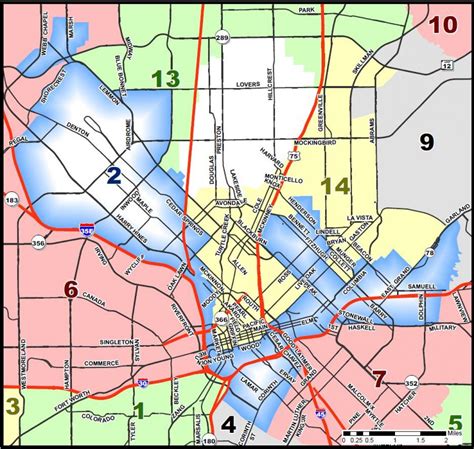
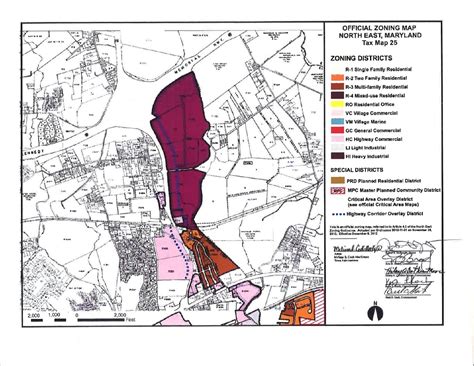
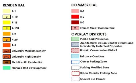
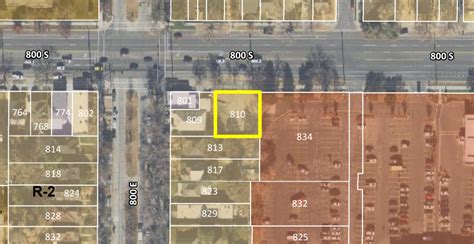
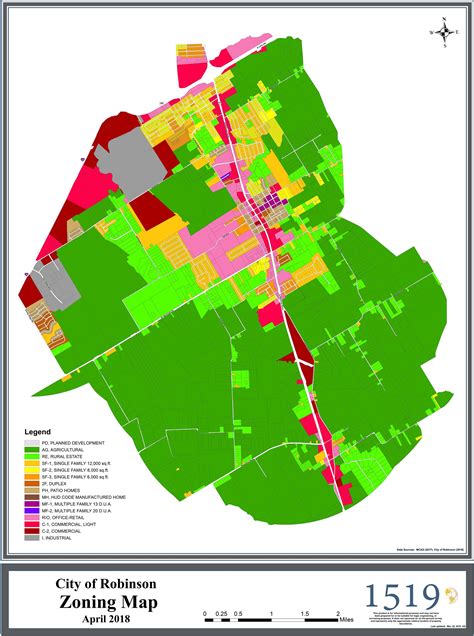
Key Features of a Dallas Zoning Map

The key features of a Dallas zoning map play a crucial role in understanding the regulations and restrictions that apply to properties within the city. One of the primary features of a zoning map is the division of the city into different zones, each with its own set of regulations governing land use and development. These zones are typically color-coded or labeled to indicate whether they are residential, commercial, industrial, or mixed-use areas.
Another important feature of a Dallas zoning map is the inclusion of specific zoning designations for individual properties. These designations determine how a particular piece of land can be used, such as for single-family residential, multi-family residential, or various types of commercial and industrial purposes. Understanding these designations is essential for property owners and developers looking to invest in or develop land within the city.
In addition, Dallas zoning maps often include overlay districts, which impose additional regulations and requirements on specific areas. These overlay districts may be related to historical preservation, environmental protection, or other special considerations that apply to certain parts of the city. By consulting the zoning map, property owners can identify whether their land is subject to any overlay district regulations.
Furthermore, a Dallas zoning map may also show areas that are subject to zoning map amendments or rezoning. These changes to the map can have a significant impact on property values and development opportunities, making it essential for stakeholders to stay informed about potential updates.
Overall, the key features of a Dallas zoning map provide valuable information for property owners, developers, and city planners. By understanding these features, individuals can navigate the complexities of zoning regulations and make informed decisions about land use and development within the city.
Types of Zoning Designations in Dallas
When it comes to understanding the types of zoning designations in Dallas, it’s important to grasp the different categories that exist within the city. These designations play a crucial role in the regulation and development of properties, as they outline the specific allowed uses and restrictions for each area.
One of the primary zoning designations in Dallas is Residential, which encompasses areas designated for single-family homes, apartments, and other dwellings. These zones are often characterized by their focus on providing living spaces for residents, with restrictions on commercial and industrial activities.
Another important designation is Commercial, which is designated for businesses, retail stores, restaurants, and other commercial activities. These areas are typically located in the heart of the city or in designated commercial districts, where the focus is on promoting economic growth and providing goods and services to the community.
Industrial zoning is another key designation, which is designated for manufacturing, warehousing, and other industrial activities. These areas are often located on the outskirts of the city to minimize the impact on residential and commercial areas, while still providing space for important industrial functions.
Finally, there are specialized zoning designations such as Historic Overlay Districts, Planned Development Districts, and Mixed-Use zones, each with their own unique regulations and requirements aimed at preserving historical structures, allowing for flexible development, and promoting a mix of residential and commercial uses within a single area.
Zoning Map Amendments and Rezoning
Zoning Map Amendments and Rezoning
Zoning map amendments and rezoning are crucial processes that affect the development and use of land in Dallas. Zoning map amendments can change the zoning of a particular property, while rezoning refers to the process of changing the zoning regulations for a specific area. These processes typically involve a thorough evaluation of the current zoning regulations and a consideration of the potential impacts of the proposed changes on the surrounding community.
When a property owner or developer seeks a zoning map amendment or rezoning, they must follow a specific protocol outlined by the city of Dallas. This may involve submitting an application, attending public hearings, and gaining approval from the local zoning authority. The goal of these processes is to ensure that any changes made to the zoning map are in line with the long-term planning goals of the city and that they do not have a detrimental impact on neighboring properties.
It’s important to note that zoning map amendments and rezoning can have significant implications for property values, the character of a neighborhood, and the overall urban landscape of Dallas. As such, these processes are often heavily scrutinized and subject to community input and review. Property owners and developers must carefully consider the potential benefits and drawbacks of seeking a zoning map amendment or rezoning and be prepared to engage with stakeholders throughout the process.
Overall, zoning map amendments and rezoning play a crucial role in shaping the built environment of Dallas. These processes require careful consideration of the social, economic, and environmental impacts of any proposed changes to the zoning map, and they often serve as a reflection of the city’s values and priorities when it comes to land use and development. As such, property owners and developers must approach these processes with a deep understanding of the implications and a commitment to collaboration and transparency.
How to Interpret a Dallas Zoning Map

Understanding a Dallas zoning map is crucial for property developers, real estate investors, and anyone looking to understand the regulations and restrictions in a specific area. Zoning maps are created by local governments to designate different areas for specific land uses, such as residential, commercial, industrial, or agricultural. These designations determine what type of buildings and activities are allowed in each zone and play a vital role in urban planning and development.
When interpreting a Dallas zoning map, it’s essential to know the key features and symbols used to represent different zoning designations. For example, residential areas may be marked with R1 for single-family homes and R3 for multi-family dwellings, while commercial areas may be designated as C1 or C2 depending on the scale of commercial activity allowed.
Moreover, understanding the legend or key provided with the zoning map is crucial to interpreting the different colors, patterns, and labels on the map. It’s important to pay attention to any overlays or special districts that may impose additional regulations or requirements on top of the base zoning designations.
Property developers and investors looking to make the most of a Dallas zoning map should also consider consulting with local planning officials or zoning experts to gain a more in-depth understanding of the regulations and potential opportunities within specific zones. By understanding the intricacies of zoning maps, individuals can make informed decisions regarding property development, investment, and land use in Dallas.
Using Zoning Maps for Property Development
When it comes to property development, zoning maps play a crucial role in the decision-making process. Zoning maps provide valuable information about the land use regulations in a specific area, which can have a significant impact on the development potential of a property.
One of the key ways to utilize a zoning map for property development is to identify the zoning designation of the land. Different zoning designations come with different permitted uses and development standards, so understanding the specific zoning designation of a property is essential for determining what type of development is allowed in that area.
Furthermore, zoning maps can also be used to identify adjacent zoning districts and understand the development potential of neighboring properties. This information can be valuable for developers looking to assess the market potential of a particular area and make informed decisions about potential development opportunities.
Additionally, zoning maps can be used to identify zoning overlays that may affect the development process. Zoning overlays are additional regulations that apply to specific areas, such as historic preservation districts or environmental protection zones. Understanding these overlays is important for ensuring compliance with all relevant regulations during the property development process.
In conclusion, zoning maps are a valuable tool for property developers, providing essential information about land use regulations, zoning designations, adjacent zoning districts, and overlays. By utilizing zoning maps effectively, developers can make informed decisions about property development opportunities and ensure compliance with all relevant regulations.
Challenges of Zoning Regulations in Dallas

One of the biggest challenges of zoning regulations in Dallas is the constantly changing landscape of the city. As the population grows and urban development continues, the demand for different types of zoning designations becomes more complex. This can lead to conflicts between different interests, such as residential areas conflicting with new commercial developments.
Another challenge is the need for zoning map amendments and rezoning in order to adapt to the evolving needs of the city. This requires a thorough understanding of the existing zoning regulations and the potential impact of proposed changes. It can be a lengthy and complex process, involving input from various stakeholders and city officials.
The interpretation of a Dallas zoning map can also pose challenges, as it requires a deep understanding of the specific zoning designations and their implications. This can be particularly challenging for property developers and investors who need to navigate the zoning regulations in order to maximize the potential of their investments.
Furthermore, the implementation and enforcement of zoning regulations in Dallas can be challenging due to the need for transparency and fairness. It is important for the city to effectively communicate the zoning laws and ensure that they are consistently applied across different neighborhoods and developments.
In conclusion, the challenges of zoning regulations in Dallas highlight the need for a comprehensive and adaptable approach to urban planning. By addressing these challenges, the city can ensure sustainable and equitable development for the future.
Future of Dallas Zoning Map Updates
The future of Dallas zoning map updates looks promising as the city continues to grow and evolve. With the rapid expansion of urban areas and increasing population, the need for efficient land use planning has become more crucial than ever. As a result, the zoning map of Dallas will need to adapt and change to keep up with the city’s development.
One of the key aspects impacting the future of zoning map updates in Dallas is technological advancements. With the advent of new mapping technologies and geographic information systems (GIS), the process of creating and updating zoning maps has become more streamlined and accurate. These technological tools enhance the city’s ability to analyze and visualize spatial data, allowing for more efficient decision-making in zoning regulations and land use planning.
In addition to technological advancements, the demands and preferences of the community also play a significant role in shaping the future of Dallas zoning map updates. As the city continues to develop, the needs and priorities of its residents and businesses will evolve. This may lead to changes in zoning regulations and updates to the zoning map to accommodate new developments, promote sustainable growth, and ensure the well-being of the community.
Furthermore, the implementation of smart city initiatives and sustainable urban planning practices will likely influence the future of Dallas zoning map updates. With a focus on environmental conservation, efficient use of resources, and community well-being, the zoning map updates may reflect a shift towards more sustainable and eco-friendly land use regulations. This could involve the identification of areas for green spaces, promoting mixed-use developments, and encouraging sustainable transportation options.
In conclusion, the future of Dallas zoning map updates is marked by technological advancements, evolving community needs, and a focus on sustainability. As the city continues to grow and transform, the zoning map will undergo updates to accommodate these changes and ensure efficient land use planning for the benefit of all residents and businesses in Dallas.
Frequently Asked Questions

What is a zoning map?
A zoning map is a map of a city or town that outlines the different zones or areas designated for specific land use, such as residential, commercial, industrial, or agricultural.
Where can I find the Dallas zoning map?
The Dallas zoning map is available on the official website of the Dallas City Hall or the city’s planning department.
How do I interpret the Dallas zoning map?
The Dallas zoning map uses color codes or symbols to indicate the different zoning districts, and it also includes a key or legend to help users understand the various zoning designations.
Can I request a physical copy of the Dallas zoning map?
Yes, you can request a physical copy of the Dallas zoning map from the city’s planning department or relevant municipal office.
What are the benefits of using the Dallas zoning map?
The Dallas zoning map helps residents, developers, and city officials understand the land use regulations and make informed decisions about property development and zoning changes.
Are there any proposed changes to the Dallas zoning map?
You can stay updated on any proposed changes to the Dallas zoning map by attending city council meetings, checking the city’s planning department website, or subscribing to relevant news updates.
Can I appeal a zoning decision on the Dallas zoning map?
Yes, if you are directly affected by a zoning decision on the Dallas zoning map, you may have the right to appeal the decision through the city’s zoning board or appeals process.